
- Explore
- Broadcast
- Activities
- Wildlife
- Historical Tours
- Cultural Tours
- Local Tours
- Adventure
- Blog
Short Itinerary
Day 1: Dehradun to Himri - 7 h drive
Day 2: Himri to Bheetri (2,500 m) to Kurla Thach (2,600 m) - 1 h drive + 5-6 h trek
Day 3: Kurla (2,600 m) to Rikatik Odi (3,520 m) - 6-7 h
Day 4: Rikatik Odi to Devbasa (3,650 m) - 5-6 h
Day 5: Devbasa to Baraadsar lake (4,300 m) via Baraadsar Ridge (4,400 m)
Day 6: Baraadsar lake to Devbasa - 4-5 h
Day 7: Devbasa to Surau forest- 7-8 h
Day 8: Surau forest to Boincha (2,000 m)- 7-8 h
Day 9: Boincha to Jakhol trek; Drive to Dehradun- 7 h
Detailed Itinerary
Day 01 : Dehradun to Himri drive, 7 hours' drive 190 km
We start the day early from Dehradun and travel to the Tons valley. The route is extremely beautiful and one winds up into the mountains via Nainbag and Damta. Purola is the last big village on the route with good network connectivity. It is a beautiful place with scenic farmlands. After Purola we cut into the Tons valley and cross Mori and Netwar. From Netwar we follow the Rupin river upwards. Himri is roughly half way between Netwar and Dhaula. We break for the day and camp by the river side. Rupin has clear blue water that rumbles down the hills.
Day 02 : Himri to Bheetri (2,500 m) to Kurla Thach (2,600 m), 1 hour drive 5-6 hours' trek: 8 km
We leave Himri after breakfast. Jeeps are arranged for travel to Bheetri, which is the last motorable village on our route. Bheetri stands at roughly 2,500 m altitude from sea level. For its altitude, Bheetri is a large village with over a hundred households. The village folks are mostly agrarian. The local deity is Sherkudeya Devta, or the Whistling God, and like in all villages of the area, a big temple stands in his honor in the center of the village courtyard. From Bheetri we start the journey on foot. We cross the village and after a short distance of 2 km we come across Sarutaal, a beautiful seasonal pond at the edge of the cliff. The lake and the cliff overlook the Rupin valley below. After a short break to catch our breath and enjoy the view, we move further. Forest cover starts soon. A 6 km hike gets us to our destination for the day - Kurla Thaach (2,600 m). A thaach is a grassy opening in the middle of the forest. These grassy meadows are home for Gujjars and their herds of cattle and equines. You can easily spot cows, buffaloes, horses and mules grazing in the grassy pastures. These animals are domestic in nature and do not pose a threat but one should refrain from getting too close to them lest we frighten them. We spend the night at Kurla.
Day 03 : Kurla (2,600 m) to Rikatik Odi (3,520 m), 6-7 hours trek: 8 km
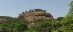
We start early next morning and begin our ascent upwards. We leave the forest behind after a couple of kilometers and reach the top of the mountain face. This spot is called Simon Tee and it offers a great view of the higher peaks of the vicinity. We continue along the mountain tops. There is a slight elevation as we move forward. We cross a ridge and reach Rikatik Odi which is the connecting point between the Rupin and Supin valley. On the Rupin side of the ridge we have the Bheetri and Dhaula villages. On the Supin side of the ridge we have Kasla and Fitadi villages. Rikatik Odi is fairly high in altitude (approximately 3,520 m) and lacks dense vegetation. There are no trees at this height, just shrubs and grasses. In the spring season there are many flowers to be observed on the slopes. Rikatik Odi offers a few good camping sites and we settle there for the night.
Day 04 : Rikatik Odi to Devbasa (3,650 m), 5-6 hours trek: 8 km
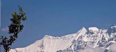
We continue forth and reach Daldar, a grassy top that is occupied by goatherds and shepherds. Beware of the guard dogs! Daldar offers excellent view of the snow capped peaks of greater Himalayas. It is also a good spot to see the local peaks like Kedar Kantha and the route to Bali Pass. On the other side, you can see the Sewa village, which lies on the route to Rupin Pass trek. We move further 3 km and reach Devbasa after a slight descent. Devbasa is a good place to camp with ample water and firewood. It also offers a spectacular view of the Surau forest which will be a camping spot on our way back.
Day 05 : Devbasa to Baraadsar lake (4,300 m) via Baraadsar Ridge (4,400 m), 6-7 hours trek: 10 km
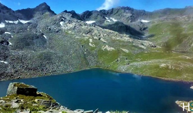
The trek on this day is mostly uphill and tedious. From Devbasa we start a steep climb up to the Baraadsar ridge. Baraadsar ridge is the highest point of the trek at an altitude of 4,400 m. We are likely to encounter snow and glaciers on the way. The ridge is a tricky climb. One notices a remarkable lack of vegetation as we climb the ridge and leave Devbasa behind. The grasses and flowery meadows are replaced by rocks and stones. On the other side of the ridge there is a welcome descent and the sound of rumbling water as glaciers melt into streams. The view is exhilarating and refreshing. We descend to the level areas and reach the lake, hidden behind a cliff. The lake is a beautiful sight surrounded by towering cliffs on one side and slopes on the other. In the colder months one can see the lake partially frozen. The lake gives rise to a stream that flows down from one end. The source of the lake is a mystery among the locals but it is mostly fed by the glaciers and snow on the sorrounding ridges. We camp close to Baraadsar lake.
Day 06 : Baraadsar lake to Devbasa, 5-6 h trek: 8 km
After having our fill of the lake we start the return journey to Devbasa. The steep Bharaadsar ridge is as tricky going down as it is coming up. We slowly and surely return back to the greener terrains of Devbasa and camp for the night. One can spot the Baraadsar ridge from here to get a sense of the towering heights scaled during the last 48 hours. We relax and enjoy the camp at Devbasa.
Day 07 : Devbasa to Surau forest, 4-5 h trek: 6 km
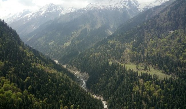
The day can start late as there is little distance to be covered. From Devbasa we pack and move up to Daldar, the goatherds's haunt. From Daldar we turn towards the Supin valley as opposed to the Rupin valley on our way up. As we enter the Supin valley, forests surround us again. There are streams of crystal clear water flowing that make for picturesque scenes. This is the Surau forest. One can spot the Himalayan Gray Langur or Hanuman Langur jumping the branches of the trees. Parakeets and Monals are also spotted in these forests. And there is always the occasional bovine herd grazing in peace. We camp in a clearing in the forest that offers a view of Lewari village on the opposite mountain face. Rala village can be seen below.
Day 08 : Surau forest to Boincha (2,000 m), 4-5 hours trek: 8 km
We cross the villages of Rala and Kasla immediately on our way down. These villages are small. They share their temple across the valley with the Lewari village. The villages are surrounded by fields that grow paddy, rajma and potatoes. A few kilometers further from Kasla, we reach the Fitadi village which is a large village on this side of the mountain. From Fitadi we turn sharply in the direction of the valley. Boincha is an open area near the river bed at the altitude of about 2,000 m. There are open areas on both sides of the river that make for good camping sites. We can spend the night here. Boincha also overlooks the Obra valley which offers some beautiful treks like Devkira.
Day 09 : Boincha to Jakhol trek; Drive to Dehradun, 5 km trek : 2 h 7 h drive: 190 km
Jakhol is a small village on the other side of the Supin valley. We start our last leg of the journey after some breakfast and walk till Jakhol. From here we drive back to Dehradun.


