
- Explore
- Broadcast
- Activities
- Wildlife
- Historical Tours
- Cultural Tours
- Local Tours
- Adventure
- Blog
Max Altitude :- 16,200 Ft.
Approx Trekking Km :- 60 Kms.
Brief Itinerary
Day 01 : Dehradun to Sankri
• Altitude: 1,950m/6,400ft (Sankri).
• 220 km drive - approx 10 hours.
• Pick up time 06.00 am at the parking of Dehradun railway station.
• Expected arrival time to Sankri – 5:00 pm.
• Keep original and copy of ID proof handy, have to show at the forest check post of Sankri.
• Available network BSNL (erratic).
• Breakfast and lunch on the way (not included in the cost).
• After Pulora keep a warm jacket handy.
• Local Market is available.
• Full functioning AMT at Pulora.
• Sankari is the last road head to the Govind Balabh Pant Wildlife Sanctuary.
• Dinner at guest house (included in the cost).
• Stay in Guest House (twin or triple sharing).
Day 02 : Sankri to Seema via Taluka
• Altitude: 2,600m/8,500ft (Seema) and 2,100m/6,700ft (Taluka).
• Altitude difference: 650m/2,100ft.
• Sankri to Taluka drive 12km, 1 hour.
• Taluka to Seema trek 12km, 7-8 hours.
• Most of the trail is gradual ascent.
• Walk though the Supin River.
• Trek is in the forest of Deodar trees, Bamboo, wild roses, irises and chestnut.
• Enough source of water on the way.
• Osla village is opposite to Seema.
• Packed lunch on the way.
• Stay in tent (Twin sharing).
Day 03 : Seema to Rainbasera
• Altitude: 3,100m/10,200ft.
• Altitude difference: 500m/1,700ft.
• Trek: 10km, 6-7 hours.
• Moderate to difficult ascent and descent.
• Can see the confluence of Har Ki Dun and Ruinsara rivers.
• magnificent view of Black Peak (Kala Nag) from Debshu Bugyal.
• Trek along with the Ruinsara river.
• Mixed scenery of forest, meadows and boulders.
• Enough source of water.
• Packed lunch for the day.
• Stay in tent.
Day 04 : Rainbasera to Ruinsara Tal
• Altitude: 3,600m/11,800ft (Ruinsara Tal).
• Altitude difference: 500m/1,700ft.
• Trek: 7 km, 4-5 hours.
• Moderate ascent.
• Ruinsara lake is surrounded by meadows and rhododendron bushes.
• Mixed trail of boulders and meadows.
• Can see waterfall on the way.
• Enough source of water.
• View from camp site: Yamuna Kanta (the pass which takes you to Yamunotri), Banderpooch Peak, Dhumdhar Kandi Black Peak (Kala Nag) and White Peak.
• Packed lunch on the way and light lunch at camp site.
• Camping near by the lake.
• Stay in tent.
Day 05 : Ruinsara Tal to Odari
• Altitude: 4,000m/13,100ft.
• Altitude difference: 400m/1,300ft.
• Trek: 4km, 3-4 hours.
• Peaks: Swargarohini.
• Steep and gradual mixed ascent.
• Limited source of water.
• River crossing by making human chain.
• Odari means a naturally made rock cave.
• it is believed that Bali (Hanuman's brother) stayed in Odari for one night.
• Hot lunch at the camp site.
• Stay in tent.
Day 06 : Odari to Bali col camp
• Altitude: 4,600m/15,100ft.
• Altitude difference: 600m/2,000ft.
• Trek: 5 km, 6-7 hours.
• Steep and technical ascent .
• walk on a mountain ridge.
• No source of water.
• Packed lunch on the way and lite lunch at camp site.
• Stay in tent.
Day 07 : Bali col cmap to Lower Dhamni via Bali Pass
• Altitude: Bali Pass 4,950m/16,200ft, Lowar Dhamni 3,400m/11,100ft.
• Altitude difference: -1,200m/4,000ft.
• Trek: 14km, 10-11 hours.
• Steep and technical ascent of 1-1.5 hours till the Bali Pass.
• Summit View: Bandarpoonch, Kalanag (Black Peak), Ruinsara and Yamuntori side, logical route to Saptarishikund.
• After Bali pass, half of the trek is technical descent.
• Always stay with Trek Leader or Guide because the route after the pass is confusing.
• Packed lunch on the way.
• Carry enough water from your camp site (Bali col).
• Stay in tent.
Day 08 : Lower Dhamni to Jaan ki Chatti and drive to Dehradun
• Altitude: 2,600m/8,500ft. (Jaan ki Chatti)
• Altitude difference: 800m/2600ft.
• Trek: 8km, 4-5 hours.
• Easy and well-defined trail.
• Enough source of water.
• Packed Lunch for the trek.
• 170km, 7hours drive.
• You will be dropped at Dehradun station in a Tata Sumo or a similar vehicle.
• Drop to Dehradun is included in the cost.
• Lunch on the way (not included in the cost).
• Driving time to Dehradun may increase due to of heavy traffic. Make your further travel plane from Dehradun after 8:00 pm.
Note:-
• Distance, Altitude and Trekking hours are approximate and round off
• Keep original and copy of ID proof handy, have to show at the forest check post of Sankri
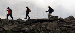
Who Can Participate?
• First timer can apply, previous trekking experience is more appreciated.
• The climber must be fit and have sufficient stamina to cover 6 km of distance in 30 minutes without a stress.
• The climber should be able to carry a 10-15 kg backpack.
• Heart problem, high blood pressure, asthma, and epilepsy cannot be reconciled on this mission. The climber must not have the conditions mentioned above.
Detailed Itinerary
Day 01 : Dehradun to Sankri
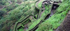
The first stop before Bali pass trek begins is the base village Sankri. It is a small hamlet of Uttarkashi that lies in Govind Wildlife Sanctuary. The drive from Dehradun to Sankri will take you through scenic places like. Kempty waterfalls, Nainbagh, Mussoorie etc. It is surrounded by peaks of Swargrohini and other Greater Himalayan peaks. By the time you reach Sankri the evening skies rise up forming amazing sceneries. A wonderful kickstart for the upcoming trek. Stay in hotels or homestay here.
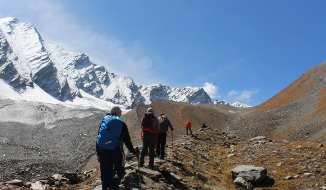
Day 02 : Sankri to Seema via Taluka
Have your breakfast and get started for the early morning drive to Taluka. It is where our actual trekking starts. The driveway of 12 km goes by crossing major streams, bamboo and deodar trees. It like turning over numerous mountain bends. There is camping near Forest Rest house, in many cases, trekkers camp here also.
Start walking from Taluka on a stone-way that descend to down to river bed. Here onwards the path is along with the Supin river. After crossing 2-3 bridges both wooden and cement the path becomes ascending gradually. After about an hour open grounds will be seen on the left. You can find many locals busy in their work around here. They greet with happy faces. Another 2 hours walk and you will find beautiful unseen wooden architectures. That is Ghangad village. Another 20 minutes walk to reach the dhaba and water run mill.
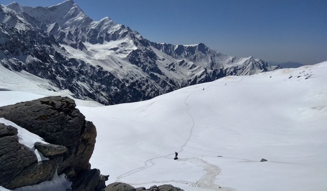
We continue from here for another hour to reach another camping ground that has a building construction in process. You will spot a wooden bridge that goes to Osla village. If you have heard, Osla is a popular tourist place these days due to its unique wooden houses. Now keep walking under forest cover besides Supin river for 60 minutes to reach Seema. Keep eyes wide open in the forests, you can spot Himalayan Monal. Seema is only a camping place, where you can find many trekkers. Stay in tents and relax for the night.
Day 03 : Seema to Rainbasera
Start fresh to reach our first big spot Debshu Bugyal. Begin by walking along the Supin river, again on the left. The trail ascends today and gets steep as you get close to Debshu Bugyal. Once you arrive in Ruinsara Valley there will be boulders on the route. As you keep climbing look behind to get views of the talked about Oslo village.
Another 30 minutes of flat walk and Debshu Bugyal begins. The Bugyal is huge pastureland of 2km length, you can rest here for a while. Kala Nag and Black Peak can be seen from the meadows.
The path from here suddenly drops until you reach the river bed. The path is filled with stones and is slippery. Again you will cross a bridge here. Observe the wonderful sights around you. To your dismay, the trail has a steep climb from here. The next campsite Rainbasera has only one small hut. Watch the evening sky beside the gushing river. Many trekkers spend the serene moment next to the river bed boulders. Stay in tents.
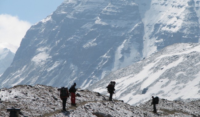
Day 04 : Rainbasera to Ruinsara Tal
This is an exciting day because the most awaited Ruinsara Lake will be our next camping ground. The trail will be like somewhat day before's. Keep walking for 3-4 hours until you reach the reflecting water body. You will see glaciers at a distance, cross streams and all kinds of adventures to reach the lake.
The camping place today will be like a dream come true in many terms. It is placed between Supin river and Ruinsara lake, surrounded by meadows with huge snow-capped mountains at the distance. The stunning peaks of Bandarpoonch range like Bandarpoonch, Kala Nag and Dhumdhar Khai and White peak dominate the skies. You can also find Yamontri temple here. Just walk around and explore the area.
Day 05 : Ruinsara Tal to Odari
Rejoice a lot today as it will be a short day of only 4 km walk. The descends down towards Supin river. The trail goes through forests and river crossing. Before arriving at the next meadows the path gets steep again. From the meadows you can see the higher peaks. This path is like a trailer of what you witnessed in the past few days.
Surprisingly, the vegetation henceforth gets sparse ahead. In a kilometre, you will reach Odari. You can find a rock cave near the camping place. Therefore the name, Odari, which means cave. It is believed that Bali (brother of Lord Krishna) halted in this cave for a night. Swargrohini 1 & 2 can also be seen clearly from here. After lunch, Trek Leader will take some training sessions that will be useful as you move higher.
Day 06 : Odari to Bali col camp
Even though this day seems shorter, it is not easy. There will steep climb on 60 degrees inclined path. It is like a ridge walk with loose rocks and scree. The trail is also laden with stones making it more difficult. Make sure you take enough rest and drink water. The height gain is significant, therefore, take proper precautions to avoid AMS.
The temperatures at night tend to go below sub-zero degrees. It is recommended to be prepared for the cold. After the strainful, rest in tents.
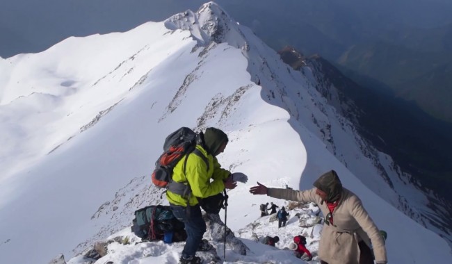
Day 07 : Bali col cmap to Lower Dhamni via Bali Pass
You can consider this as the summit day. Today you will be crossing the Bali Pass to reach Lower Dhamni. Eat full for sufficient energy for the long day. The trail to Bali pass is steep and has lots of snow. There follow the path broken your guides only. There is no need for roping up but wear microspikes if required.
After a steep climb of 2-3 hours, you will reach the top of the pass. The pass is only 10 feet wide and 30 feet wide. The pass is the high point you will feel like standing on a mountain top. Relish the 360-degree view of Swargarohini, Banderpooch and Garhwal peaks. Enjoy the views of Yamnotri valley on the right. Make the most of the sights and the moment. Hold your breath for the descend, because the actual thrill will begin now.
The climbing down is almost at 90 degrees with a narrow path. Use proper techniques and follow your guide carefully. Even after the leg section, until upper Dhamni the path is extremely tricky so be careful. It may also be strainful due to snow. After this challenging part, rest at Upper Dhamni. The path from leg to Dhamni is confusing, like a maze therefore, make sure to be in a team and follow your guide.
After taking rest, we will resume our trek to Lower Dhamni. The path is a confusing one and therefore it is advised to stay with your trek leader and team. The trail from here will be flat and visible. The path is through the forest and 2-3 km long. Rest in your tents. This will last stay in tents.
Day 08 : Lower Dhamni to Jaan ki Chatti and Drive to Dehradun
The last day of the trek has finally arrived. This will be easiest day filled a lot of descends and mild ascend. The trail is a well-paved cement pathway. There is a slight ascend up to Yamunotri which may take another 1-2 hours. Leave early from the campsite to reach Dehradun.
How to Reach
By Air :-
Jolly Grant Airport is the airport serving Dehradun, located about 25 km from the city. There is a daily flight from Delhi to Dehradun
By Train :-
Take the overnight train to Dehradun from Delhi
• Nandadevi Express - Train no: 12205 (Departure 11:50pm; Arrival - 5:40am)
• Dehradun Express - Train no: 12687 (Departure - 9:10pm; Arrival - 5:00am)
By Bus :-
There is regular bus service from Delhi to Dehradun, from Delhis ISBT Kashmere Gate.
We would suggest you to take only government buses from ISBT Kashmere Gate. Private buses ply from outside ISBT and they are not trust worthiness.
Usually buses drop you at Dehradun ISBT. From there you have to come to Dehradun Railway Station
• TTH’s Tata Sumo or similar vehicles will pick-up you from Dehradun Railway Station at 6:00am.
• Pick-up is included in the cost of the trek
• You will reach Sankri by 5:00 pm
• Food from dehradun to Sankri is not included in the trek cost


