
- Explore
- Broadcast
- Activities
- Wildlife
- Historical Tours
- Cultural Tours
- Local Tours
- Adventure
- Blog
Max Altitude :- 18,000 Ft.
Approx Trekking Km :- 95 Kms.
Brief Itinerary
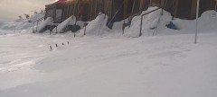
Day 1 : Dehradun to Gangotri
• Altitude: 3,100m/10,200ft (Gangotri).
• Pick up time 06.00 am at the parking of Dehradun railway station.
• Drive 240 km, 8-9 hours from Dehradun.
• Breakfast and lunch on the way (not included in the cost)
• After Uttarkashi keep a warm jacket handy.
• Local Market and network is available.
• Full functioning AMT at Uttarkashi.
• Gangotri is one of Char Dhams of Uttarakhand.
• Dinner at guest house (included in the cost)
• Stay in Guest House (double or triple sharing).
Day 2 : Rest and acclimatisation at Gangotri
• After breakfast visit Pandav gufa, Gauri and Surya kund.
• Post lunch can visit Gangotri temple or go for shopping.
• Lunch at guest house.
• Stay in Guest House.
Day 3 : Gangotri to Nala Camp
• Altitude: 3,750m/12,300ft (Nala Camp).
• Altitude gain: 650m/2,100ft.
• Trek: 8km, 6-7 hours.
• Moderate walk with steep ascent.
• Walk along with the river.
• Initial trail is with Bhagirathi River and with Rudugaira River.
• After 2hours of trek cross the river over a log bridge.
• Walk in the forest of Pine, Cedar, Rhododendrons and Birch trees.
• Cross Bhoj Kharak camp (camp for Rudugaira peak).
• Can see Gangotri III and Jogin II just before the campsite.
• Packed lunch on the way.
• Stay in tent (Twin sharing)
Day 4 : Nala Camp to Rudugaira Camp
• Altitude: 4,350m/14,300ft (Rudugaira Camp)
• Altitude gain: 600m/2,000ft.
• Trek: 7km, 7-8 hours.
• Steep and strenuous climb all the way.
• Views of Rudragaira peak, Jogin peak and Auden Col pass.
• Cross a stream and landslide area.
• Less water sources on the way.
• Packed lunch for the day.
• Stay in tent.
Day 5 : Rest and Acclimatization
• An acclimatization day at this height is mandatory.
• Explore and enjoy campsite surrounded by peaks.
• Can climbed a ridge towards Rudragaira peak.
• Hot lunch at campsite.
• Stay in tent
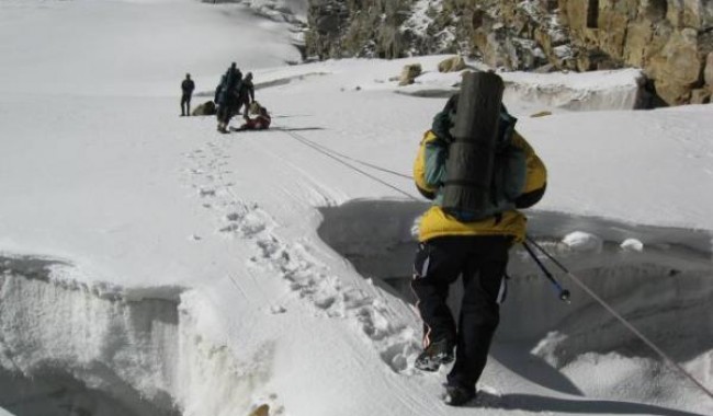
Day 6 : Rudugaira Base Camp to Auden's Col Base Camp via Gangotri Base Camp
• Altitude: 4,750m/15,600ft (Auden’s Col BC.)
• Altitude gain: 400m/1,300ft.
• Trek: 8km, 6-7 hours.
• Gradual and tricky ascent on moraine.
• Carry enough water from the campsite.
• Beautiful views of Gangotri peaks.
• Pass Sukha Tal on the way.
• Can see the gully leading to Auden's Col.
• Packed lunch on the way.
• Stay in tent.
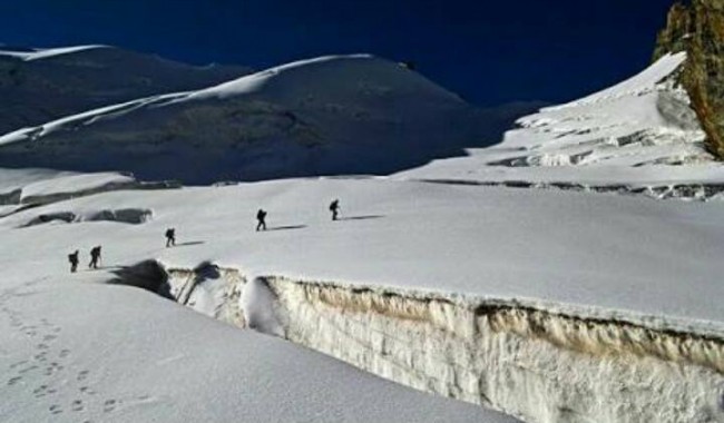
Day 7 : Auden's Col Base Camp to Khatling Glacier Camp via Auden's Col
• Altitude: 5,490m/18,000ft (Auden’s Col), 5000m/16,400ft (Khatling Glacier).
• Altitude gain: 750m/2,500ft
• Trek: 12km, 9-11 hours.
• Camp to Auden’s Col 5km, 4-5 hours.
• Auden’s Col to Khatling Glacier 7km, 5-6 hours.
• Start early in the morning.
• Difficult walk, steep ascent till the Col after that steep descent.
• Descent is more tricky and difficult the ascent.
• Toughest climb of the trek.
• Khatling Glacier is famous for deep crevasses.
• Always roped up and walk with trek leader/guide to avoid slip and fall.
• Carry sufficient water from campsite.
• Packed lunch for the day.
• Stay in tent.
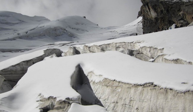
Day 8 : Khatling Glacier Camp to Zero Point/Waterfall Camp
• Altitude: 3,900m/12,800ft (Zero Point).
• Altitude loss: 1,100m/ 3,600ft.
• Trek: 11km, 9-10 hours.
• 8 km trek is on glacier.
• First half of trail is mixed of loose grave, scree, black ice.
• Rest of the trail is of moraine.
• Camp by the Bhilangna river.
• Bhilangna river ends at Tehri dam.
• Packed lunch for the day.
• Stay in tent.
Day 9 : Rest Day
• Mandatory Rest day.
• Rejuvenate yourself.
• This day also can be used as a buffer day.
Day 10 : Waterfall Camp/ Zero Point to Chowki
• Altitude: 3,500m/11,500ft (Chowki)
• Altitude Loss: 400m/1,300ft.
• Trek: 8km, 5-6 hours
• Comparatively easy day.
• Will see greenery again.
• Most of the trek is on Meadow.
• Fallow Bhilangna river for first 3km.
• Campsite is on grass land.
• One of the best campsite of the trek.
• Packed/hot lunch, depends on the pace of the group.
• Stay in tent.
Day 11 : Chowki to Masar Tal
• Altitude: 3,750m/12,300ft (Masar Tal)
• Altitude gain: 250m/800ft.
• Trek: 8km, 5-6 hours.
• Easy day.
• Initially steep ascent then gradual walk.
• Trail is well defined.
• Can see the beautiful views of Thalay Sagar peak.
• Camping near by the Masar Tal (lake).
• Stay in tent.
Day 12 : Masar Tal to Vasuki Tal via Mayali Pass
• Altitude: 5,000m/16,400ft (Mayali Pass)
• Altitude: 4,200m/13,800ft (Vasuki Tal)
• Altitude gain: 1,250m/4,100ft.
• Trek: 12km, 7-9 hours.
• Steep ascent till Mayali Pass.
• Steep and technical descent after Mayali Pass.
• Trail is of boulders and snow.
• No water source on the way
• Camping near by the Vasuki tal (Lake).
• Packed lunch on the way.
• Stay in tent.
Day 13 : Vasuki Tal to Kedarnath
• Altitude: 3,550m/11,600ft (Kedarnath)
• Altitude loss: 1,450m/4,800ft.
• Trek: 7km, 3-5 hours.
• All descent till Kedarnath Temple.
• Easy and marked trail.
• Kedarnath temple is dedicated to Lord Shiva.
• Visit Kedarnath temple in the evening.
• Hot lunch at guest house.
• Stay in guest house.
Day 14 : Kedarnath to Gaurikund
• Altitude: 1,950m/6400ft (Gaurikund)
• Altitude loss: 1,450m/4,800ft.
• Trek: 14km, 5-6 hours.
• All descent till Gaurikund.
• Easy and marked trail.
• Many shops and water point on the way.
• Can go by helicopter (not included in cost).
• Hot lunch at guest house.
• Stay in guest house.
Day 15 : Gaurikund to Dehradun
• 250km, 8-10hours drive.
• You will be dropped at Dehradun station in a Tata Sumo or a similar vehicle.
• Drop to Dehradun is included in the cost.
• Breakfast and lunch on the way (not included in the cost).
• Driving time to Dehradun may increase due to of heavy traffic. Make your further travel plane from Dehradun after 8:00 pm.
Note:
• Distance, Altitude and Trekking hours are approximate and round off. Distance, Altitude and Trekking hours are approximate and round off.
• Keep original and copy of ID proof handy.
Who Can Participate?
• First timer can apply, previous trekking experience is more appreciated.
• The climber must be fit and have sufficient stamina to cover 7 km of distance in 35 minutes without a stress.
• The climber should be able to carry a 10-15 kg backpack.
• Heart problem, high blood pressure, asthma, and epilepsy cannot be reconciled on this mission. The climber must not have the conditions mentioned above.
Detailed Itinerary
Day 1 : Dehradun to Gangotri
Once you arrive at Dehradun, get all ready to start your long drive to Gangotri. As you know it is the most religious place of India. You will cross Uttarkashi, the place having NIM mountaineering institute. Uttarkashi is a town located on the banks of river Bhagirathi. The drive goes through temples and dense forests until you reach in the evening.
Gangotri is also situated on the banks of river Bhagirathi. It is one of the Char Dhams, hence, it sees a huge crowd of pilgrims in March and April. There are also many foreigners visiting. You can also roam in the market and get acquainted the locals. But, leave that for the next day and rest in your hotel.
Day 2 : Rest and acclimatisation at Gangotri
Wake up in the religious land. Today try to utilize the day to know about Gangotri. You can visit temples, caves, walk in the woods, meet Sadhus, etc. Together with the group, you can visit Surya Kund, PandavGufa and GauriKund also. Try not to miss the Aarti. Today is acclimatization day so stay outdoors and get used to the height.
Day 3 : Gangotri to Nala Camp
After good acclimatization stay in Gangotri get walking towards Nala Camp. The trek will of 8-9 hours through the moderate and steep trail. You begin by going down the main valley. You will be walking along the Bhagirathi river. After 2 km cross the log bridge on the river then take a right to enter towards Rudragaira valley. You will be walking through dense Pine, Cedar, Rhododendrons and Birch trees.
The trail then suddenly climbs up. You may also have to pass through the rockfall zone, so be careful. You will cross BhojKharak campsite. As you gain height you can see the forests becoming less visible. Later you can find grasslands bloomed with flowers then come into eyesight. You can also see a glimpse of Gangotri III and Jogin II. The camping is on the wonderful meadows beside Rudragairariver. So, enjoy it while your night stays in tents.
Day 4 : Nala Camp to Rudugaira Camp
Today will be a short yet difficult day. The entire trail is a steep and strainful climb. There will be no water sources on the way. Make sure you carry enough water. Moving through Nala the trail will go up towards high meadows.
There will be many stream crossing and landslide crossing. Take your steps carefully. Ahead you may find some snow patches and the trail getting even steeper. In spite of all the difficulty, your day will be cheerful with the stunning sights of Rudragaira peak, Jogin peak and Auden Col pass. After a strenuous day rest in your tents at Rudragaira camp.
Day 5 : Rest and Acclimatization
Since you are at 14800 feet it is necessary to give your body the time for acclimatization. Explore around the campsite. Make the most of this stunning campsite that is between huge peaks on meadows beside a gushing river. If you wish to you can go for a small hike on a ridge near the campsite. Try to stay out of the tents to boost the process of acclimatization.
Day 6 : Rudugaira Base Camp to Auden's Col Base Camp via Gangotri Base Camp
Today will be an exciting day with a lot of surprises. First, start by walking on moraines. Once you cross a landslide area you will reach the top of the ridge. Keep walking on the ridge and climb down till Bakriwala camp. After crossing a stream another ridge will come ahead. This ridge is a flat like a walk for more than an hour. The walk is tricky owing to loose scree, hence, be careful. Once you finish the ridge you will have a descend ahead.
Now climb down to Gangotri Base camp. After a climb, you will be welcomed by SukhaTaal. It is a surprise element of the trek. Base Camp is on flat moraine surface. From the camp, you can see the gully leading to Auden's Col.
Day 7 : Auden's Col Base Camp to Khatling Glacier Camp via Auden's Col
Today will be the longest, toughest and exquisite. Since days you were hoping of crossing Auden's col and today it will be done. Start by walking on the moraine, you can see Rudgragaira glacier on the right. There is a couple of snow-laden ridges following. Based on the snow level you might be instructed to wear crampons. After crossing the last ridge you will climb up a little to enter the gully.
The flat ground that comes next is used as Advanced camping site. The climb up henceforth requires roping up. When you are the Auden's pass you can see many crevasses, you might have to cross over a one or two. Therefore, follow your guide's footsteps. The snow level also may increase to knee-deep. At this height, it becomes difficult to walk. With Jogin and Gangotri peaks towering on the sides the Auden's col looks exceptional.
The views on the other side are even more stunning. You can see Khatling Glacier and its crevasses giving an instant wave of fear. The climb down is extremely steep with 70 degrees slope. The descend is scary after comes a flat glacier ground. You will be camping on this moraine land of Khatling glacier.
Day 8 : Khatling Glacier Camp to Zero Point/Waterfall Camp
Another longest and tough day. Today we will continue on the rest of the Khatling glacier to arrive at Zero Point camp. The initial 50 m is steep descend. Watch your steps. The trail will be covered with snow. Climb down the glacier for another 2 km to reach moraines.
The trail is filled with loose rocks and scree. The route is also exposed and you can see black ice, icefall and big ice formations. You will also have to find way through crevasses. From the end of Khatling glacier from the snout, Bhilangnariver originates. Cross the last section of the rockfall and boulder section to reach the campsite.
Day 9 : Rest Day
This is a purposefully added day for resting. After all the strainful and amazing trek experiences, take rest for this day. This day can be also used as a buffer day in case of unfavourable situations.
Day 10 : Waterfall Camp/ Zero Point to Chowki
After the rest day, you will be full-energized to start a wonderful day. Today will be a nice and pleasant walk through meadows. Continue walking along the valley for 3 km. You will be crossing a wooden bridge on the fiercely flowing Bhilangariver. After that, the lush meadow will welcome you. You can take a break here to relax on the beautiful meadows.
Keep walking for another 4km to the next campsite. The Chowki campsite is a beautiful setup on the huge grasslands between big mountains.
Day 11 : Chowki to Masar Tal
Today you will gain a little height to reach the crystal, Masar Tal. The day will be rejuvenated by clear views of Thalaysagar peak. The trail begins with a small ascend showing sights of Thalaysagar. You cross another few ridges. You will also cross a stream until you reach the beautiful Masar Tal. The lake reflects the scenery around it thousand times. You will be lucky to camp beside this lake.
Day 12 : Masar Tal to Vasuki Tal via Mayali Pass
Be excited because today you will visit another and the last pass of the trek, Mayali pass. The trail starts with a climb up over boulders to the Masar top. A climb up for another 45 minutes is needed to reach the base of the pass. This point is outstanding in terms of beauty. There is a lake which is at times semi-frozen with ice bergs floating on its surface.
After this a long walk is followed. The trail is somewhat flat and gradual. You will also be crossing crevasses just like at Khatling but a lot easier. The top of the pass gives a feeling victory. Enjoy for a moment then start to descend. The climbing down trail is filled with boulders and is steep. Before this you may spot the Peenya Tal twin lakes. Keep walking ahead to reach the Vasuki Tal.
Day 13 : Vasuki Tal to Kedarnath
Finally the day has arrived that will end at the mighty Kedarnath. It is one of the Char Dhaams and one of the 12 Jyotirlingas. It has a lot of prime importance in Indian religion. First, start with a ascend to Vasuki Tal top. The trail is boulder filled ridge walk.
After this point there is a steep descend continuously. You will be excited to finally see the greenland. The Kedarnath village beside Mandakiniriver looks serene. Enjoy your evening with the blessing of Lord Shiva.
Day 14 : Kedarnath to Gaurikund
This is the final stroll of the thrilling day. It is a complete long climb down of 14kms. The trail is an easy and well-marked. Try to engulf the most from the last day in the mountains.
Day 15 : Gaurikund to Dehradun
The last day of the trek has arrived. You will be boarding your vehicle taking you back to Dehradun. Collect a lot of memories and promise to come back again.
How to Reach
By Air :-
Jolly Grant Airport is the airport serving Dehradun, located about 25 km from the city. There is a daily flight from Delhi to Dehradun.
By Train :-
Take the overnight train to Dehradun from Delhi
Nandadevi Express - Train no: 12205 (Departure 11:50pm; Arrival - 5:40am)
Dehradun Express - Train no: 12687 (Departure - 9:10pm; Arrival - 5:00am)
By Bus :-
There is regular bus service from Delhi to Dehradun, from Delhis ISBT Kashmere Gate.
We would suggest you to take only government buses from ISBT Kashmere Gate. Private buses ply from outside ISBT and they are not trust worthiness.
Usually buses drop you at Dehradun ISBT. From there you have to come to Dehradun Railway Station
TTH’s Tata Sumo or similar vehicles will pick-up you from Dehradun Railway Station at 6:00am.
Pick-up is included in the cost of the trek. You will reach Gangotri by 5:00 pm


